

WMO article on floods
Englishعربي中文FrançaisРусскийEspañol
MenuOpen the search form
Search
ActivitiesTopicsNewsResourcesCommunityAbout WMO
Breadcrumb
- Home
- All Topics
- Floods

Floods
NATURAL HAZARDS
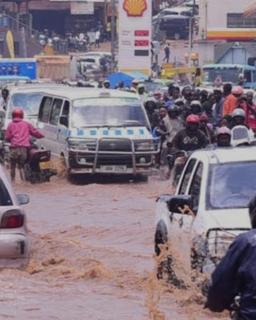
Floods are the deadliest natural hazards, striking numerous regions in the world each year.
Increasing population pressure, degradation of ecosystem and climate variability and change contribute to a further increase in flood risks worldwide.
2.5 billion
Between 1994 and 2013, floods affected nearly 2.5 billion worldwide.
$40 billion
Floods cause more than $40 billion in damage each year around the world.
24% increase
From 2000 to 2015, the number of people living in flood-prone areas increased by an estimated 58 M to 86 M, a 24% increase.
Overview
Floods are part of the natural variability in flow rates and water levels of rivers. This means that flood management plays an important role in protecting people and incorporating flood risks into the management of water resources provides a rationale to shift towards an integrated flood management approach.
During the last decades the trend in flood damages has been growing exponentially. This is a consequence of the increasing frequency of heavy precipitation, changes in upstream land-use and a continuously increasing concentration of population and assets in flood-prone areas. This is often exacerbated by inadequate flood planning and management practices.
Sea level rise has increased vulnerability to storm surge and related coastal flooding, as well.
Impact
Floods can cause widespread devastation, resulting in loss of life and damage to personal property and critical public health infrastructure. Between 1998-2017, floods affected more than 2 billion people worldwide. (Source: https://www.preventionweb.net/files/61119_credeconomiclosses.pdf)
Climate change is increasing the frequency and intensity of floods, and their impacts are exacerbated by land use changes and increased population pressure on flood-prone areas. (Source: https://www.unep.org/news-and-stories/story/how-climate-change-making-record-breaking-floods-new-normal)
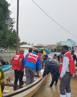
WMO’s response
Through the Flood Forecasting Initiative, WMO helps to improve the capacities of National Meteorological and Hydrological Services to jointly deliver timely and more accurate products and services for flood forecasting and warning, in collaboration with disaster managers active in flood emergency preparedness and response.
WMO, together with the Global Water Partnership has established the joint initiative of the Associated Programme on Flood Management (APFM). It promotes the concept of Integrated Flood Management (IFM) to maximize net benefits from the use of floodplains and minimize the loss of life and impacts. As such, it provides tools and publications to support flood management. To address the issues associated with flash floods, especially the lack of capacity to develop effective flash flood warnings, the Flash Flood Guidance System (FFGS) was designed and developed for interactive use by meteorological and hydrological forecasters. WMO, jointly with the U.S. Agency for International Development Bureau for Humanitarian Assistance (USAID/BHA), the U.S. National Oceanic and Atmospheric Administration/National Weather Service (NOAA) and the Hydrologic Research Center (HRC), is implementing this system throughout the world.
The APFM and the FFGS are just two of the elements that contribute to the WMO Flood Forecasting Initiative, which also oversees activities related to the WMO Long-Term Ambition “No one is surprised by a flood” such as building capacities on technical aspects related to end-to-end flood forecasting and early warning.
Related activities
Related publications

Integrated Flood Management (Concept Paper)Flood Management Policy SeriesAPFM Tool SeriesAPFM Guidance Document
Fact sheets
Related topics
Related news
Welcome to the World Meteorological Organization
Find out about employment opportunities at the WMO
The story of how our HQ came to be
View the latest tenders
WMO Awards recognize outstanding contributions
How to contact WMO
© 2024 World Meteorological Organization (WMO)
